
Hunting temporarily closed in multiple area of S.C. due to effects of Hurricane Helene

Due to extreme rainfall and widespread flooding in the Upstate of South Carolina and mountains of North Carolina due to Hurricane Helene, the South Carolina Department of Natural Resources has temporarily closed hunting within the Wateree, Congaree and Santee river drainage systems on all game species except for alligator, doves, hogs and coyotes.
The department has received contacts from numerous concerned hunters. Flooding has created abnormal conditions wherein game cannot protect themselves, thus producing the potential for exploitation of game species that are deprived of their normal escape routes and confined to small areas of high ground.
Effective Wednesday, Oct. 2, at 12:01 a.m., a five-day closure of the hunting season for all game species excluding alligator, dove, hogs and coyotes will be in effect. The closure will continue through Sunday, Oct. 6 at 11:59 p.m. SCDNR will continue to monitor flooded areas to adjust the closed zones and timeframes as conditions change.
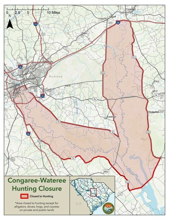
Wateree-Congaree drainage
In CALHOUN COUNTY- West side boundary: beginning on Interstate 26 at the Lexington County line, thence southeast on I-26 to the intersection of I-26 and U.S. 176. Thence southeast on U.S. 176 to the intersection with state road 24 (Old Belleville Road). Thence east on state road 24 to the intersection with state road 25 (Purple Martin Drive), thence east on state road 25 to Fort Motte, becoming S.C. 419 (Ft. Motte Road). Thence southeast on S.C. 419 to the intersection with S.C. 267 (McCords Ferry Road). Thence southeast on S.C. 267 to the CSX train line in Lone Star. Thence north on the CSX train line to the Sumter County line.
In KERSHAW COUNTY - An area bounded on the north by Interstate 20 on the south by Richland and Sumter counties, on the east by U.S. 521, from I-20 to its intersection with S.C. 261, thence south on S.C. 261 to the Sumter County line. On the west by U.S. 601 to the Richland County line.
In LEXINGTON COUNTY - West side boundary: beginning at the Richland County line on U.S. 321, thence west to I-26, thence southeast on I-26 to the Calhoun County line.
In RICHLAND COUNTY - North side boundary: the Kershaw County line. West side boundary: beginning at the Kershaw County line on U.S. 601, thence south to S.C. 48 (Bluff Road), thence west on S.C. 48 to U.S. 321. Thence west on U.S. 321 to the Lexington County line.
In SUMTER COUNTY - An area bounded as follows: on the north by the Kershaw County line, on the east by S.C. 261, on the west by the Richland and Calhoun County lines, and on the south by the CSX Railroad tracks from Pinewood to the Calhoun County line.
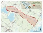
Santee drainage
In BERKELEY COUNTY- the area bounded on the north by Clarendon, Williamsburg, and Georgetown counties; on the south by S.C. 45; on the west by the old Santee Canal; and the east by Charleston County.
In CHARLESTON COUNTY: that area bounded on the west by Berkeley County; on the south by S.C. 45, on the east by U.S. 701/17, and on the north by Georgetown County.
In GEORGETOWN COUNTY- an area described as follows: beginning at the point where the Williamsburg, Berkeley and Georgetown county lines meet and running north and east along the Georgetown-Williamsburg County lines to U.S. Alternate 17 and thence running along such highway to its intersection with state road 387, thence to state road 24, and running southeast along state road 24 to its intersection with U.S. 17, thence south along U.S. 17 to the Charleston County line, thence west following the Charleston and Berkeley County lines to the point of the beginning.
In WILLIAMSBURG COUNTY- the area described as follows: beginning at the point where state road 48 (River Road) crosses the Clarendon County line and following state road 48 until its intersection with S.C. 375 (Mackey Road/Gourdin Road), thence running along said road to Gourdin, thence along state road 45 (Santee Road) to the Georgetown County line, thence south along such line to the Berkeley County line and following said line northwest to the Clarendon County line, thence northeast along said Clarendon County to state road 48.
In CLARENDON COUNTY- that area described as follows: beginning at the intersection of S.C. 260 and state road 323 (Kenwood Road), and running along state road 323 to its intersection with state road 351, thence running along state road 351 to state road 48, thence along state road 48 to the Williamsburg County line, thence along said county line to the Berkeley County line thence west along the Clarendon/Berkeley County line to Wilson Dam, thence north along said dam to S.C. 260, thence along S.C. 260 at state road 323.